Tuesday, October 25, 2011
Be Pinoy: About Cebu City
Be Pinoy: About Cebu City: C E B U "A Quintessential Destination" "click to view larger image" C ebu is one of the most favored provinces of the Ph...
Saturday, October 22, 2011
Santander, Cebu
Santander
"Mesmerizing the Wonders"
"click to view larger image"
 |
 |
Map of the Santander Island
|
Official Seal of the
Municipality of Santander |
Wander the
Municipality of Santander
Municipality of Santander
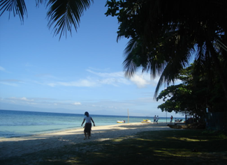
If you're bored of getting yourself in the midst of all business of the city, try to get a share of the wonders of Santander.
The municipality of Santander is located in the southernmost tip of the island of Cebu and is approximately 134.3 kilometers from Cebu City.
Geographical Location
It is bounded on the:
| -Samboan | |
| -San Jose, Negros Oriental | |
| -Bohol Sea | |
| -Bohol Sea |
Badian Information
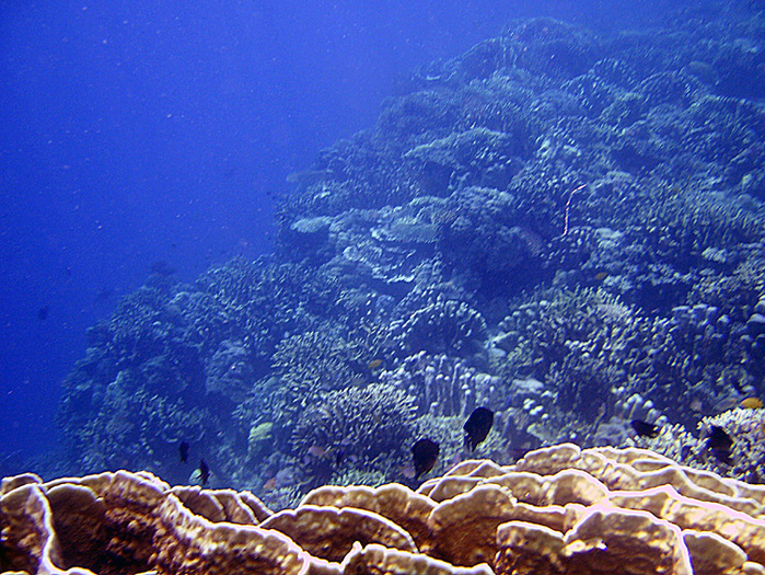
Santander is a 5th class municipality. Main crops are coin, copra and root crops. White sand beaches and watchtowers must-sees in Santander. The famous beach resorts in the area are located in Liloan, which boasts of crystal-clear waters than can compare to the beaches in mactan Island. Among the famous resorts is the Marine Village Dive House, which offers several activities for divers and non-divers. Dive enthusiasts will surely enjoy the dive sites in the municipality such as the wall of Death, a dive site for experienced divers, where one can find hand and soft cards, and different kinds of fish.
Santander is the third smallest town in Cebu. But it has turned out many professionals. Majority of the people depend on the sea for livelihood --- fishermen who continually explore the vast Palawan and China seas in search for rich fishing grounds. The methods of fishing used is the popular muro-ami.
Santander's popularity as a tourist destination has increased in the past few years. Santander is the ideal spot for diving as it's located in the hub of some world renowned dive spots like Apo Island, Balicasag, Pescador Island, Sumilon and Siquijor This is also reflected in the growth of Santander in the tourism industry. 6 years ago there were only 2 resorts, still open today. Today there are 11.
Why the municipality was named with Santander?
Santander was popularly known in the past as “Tañong” after the turbulent waters of the Tañon Strait, which surrounds the area. However, when the Spaniards came, the town’s first parish priest changed its name to Santander, the priest’s hometown, which can be found in the northern coast of Spain and is considered a chief port and a famous bathing resort.
Tañon Strait is a narrow channel about 3 kms deep, 185-km long between Cebu and Negros in central Philippines. According to sources from the Department of Agriculture - Bureau of Fisheries and Aquatic Resources, Tañon Strait is among the top ten major fishing grounds in the country. It produces big and quality fish stocks, including blue marlin and tuna. It is also famous for its schools of dolphins, attracting a growing number of foreign and local tourists each year.
However, this biodiversity rich water and adjacent waters are not spared from ecologically destructive oil exploration.
Culture and Heritage
 |
 |
 |
Tostado Festival - showcasing different performances of participating barangays.
|
||
Tostado Festival
3rd Sunday of April
3rd Sunday of April
Santander is popular for its Annual Tostado Festival where they showcase their famous "Tostado" and other delicacies.
 |
Tostado Festival Queen 2011
"1st Runner-Up" |
Tostado is a local delicacy in the town. It's a home-baked cookie with delicious taste and the procedures and secret ingredients in making a really delicious tostado have been handed down from generations to generations.
Tostado festival gives honor to the delicacy that have made Santander popular. Of course, there are a lot of things that can be attributed to Santander, but when you mention the town anywhere you go, people will remember the Tostado.
Tostado festival gives honor to the delicacy that have made Santander popular. Of course, there are a lot of things that can be attributed to Santander, but when you mention the town anywhere you go, people will remember the Tostado.
The festival focuses on the town’s famous delicacy, the “tostado”. The street dancing which is the highlight of the festivity uses the different movements of making a tostado in the dance participated in by the different barangays.
The street dancing, which is the highlight of the festivity, uses the different movements of making a tostado, and is participated by the different barangays. The town’s fiesta is also in honor of their patron, St. Gabriel. The festival is meant to promote the tostado industry of the town to other places.
 |
Tostado Bread Snacks
|
"Pasigarbo sa Sugbo Festival Queen 2011"
-Tostado Festival-
Santander, Cebu
Marine Village Dive House
Explore with us amongst the 7,107 islands known as the Pearl of the Orient Seas - a perfectly challenging experience as you go snorkeling, scuba diving or simply strolling along secluded beach coves, coral gardens, natural attractions of towering rocks island and mountain trails dramatic landscapes and fiestas...
A tropical paradise just within your reach, explore the ocean, see marine life, island hop, and go caving in Mabinay.... Get intimate with the wonders under the seaOur Rooms are laid back, cozy, a homey sanctuary with an ocean View. A beautiful lookout for the ocean, sunrise, sunset while standing at the terrace
Activities:
Short Diving
Middle Diving
Long Diving
Snorkeling / Skin Diving
Dolphin/ Whale Watching
Mountain Climbing
Island Hopping
City Tour
Caving
Golf
Corals & Fish
Water Falls Tour
Services Offered:
Massage
Reflexology
Swedish massage
Aromatherapy
Shiatsu
Manicure
Pedicure
Sample our chefs Japanese, Filipino and other continental cuisine at the restaurant.
Planning a wedding can be highly stressful, so taking a honeymoon vacation is a great way to unwind after the big day is over.
Let someone else look after you and cater to your every whim. The hardest part will be picking the destination - there are so many romantic places to choose from! It never hurts to let people know you're on your honeymoon once you arrive at your destination!
Marine Village Dive House
Transportation
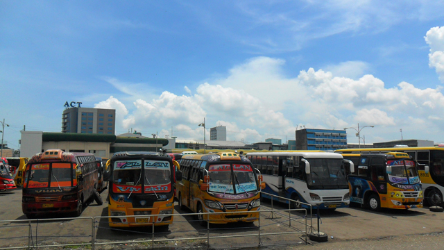
Tourists can reach the town through an approximately 3 ½ -hour bus of vehicle-for-hire ride from Cebu City. These vehicles are available every hour at the Cebu South Bus Terminal. Tricycles, trisikads, and motorcycles for hire to take care of the tourists around the town.
ROUTES
|
MEAN S OF TRANSPORTATION
|
Capacity
|
Accessibility
|
Fares*
|
CSBT-South
|
Buses (aircon)
|
66(max)
|
CSBT
(Cebu South Bus Terminal) |
P100-P160
|
CSBT-South
|
Buses(non-aircon)
|
66(max)
|
CSBT
(Cebu South Bus Terminal) |
P85-P110
|
CSBT-South
|
Mini Buses
|
40(max)
|
CSBT
(Cebu South Bus Terminal) |
P70-P100
|
*Fares vary depending on the destination point.
|
||||
Have the chance to meet and greet the people of
Municipality of Santander.
View Larger Map
Map of Cebu showing the location of Municipality of Santander.
Santander Municipality is administratively subdivided into 10 Barangays.
- Bunlan
- Cabutongan
- Kandamiang
- Liloan
- Lip-tong
- Looc
- Pasil
- Poblacion
- Canlumacad
- Talisay
Argao, Cebu
Argao
"Captivating the
Gorgeous Town of Argao"
 |
Map of the Argao
|

Your one-stop site for everything about Argao:
beaches, resorts, transportation, accommodation, crafts, arts, recreations, events, fiesta...
The municipality of Argao is located in the southeastern part of the province of Cebu and is approximately 67 kilometers from Cebu City. It is bounded by the following municipalities:
Geographical Location
|
It is bounded on the:
| North | -Municipality of Sibonga |
| South | -Municipality of Dalaguete |
| West | -Municipalities of Dumanjug, Ronda, Alcantara, Moalboal and Badian |
| East | -Bohol Strait |
Argao Information
Argao, Cebu, Philippines is located on the 2nd district province of Cebu. Composed of 45 barangays and now acknowledged as a first class municipality.
What is a barangay?
It is known to describe as a native Filipino term for village or district. Barangays are subdivided into smaller Zones or what they call as "Purok".
What is the population of Argao?
Argao is in the southern part of Cebu with a population of more or less than 62,000 people.
In one of the previous news articles, Argao was declared as the top tourist destination in Cebu. This is because of the increasing number of visitors who are interested to see the controversial place. With so much development in just a short period of time, lots of people get curious as to what Argao has to offer. Below is a list of things that you must experience when you visit the place namely:
Delicacy
The town is famous for its mouth-watering torta, lip-smacking tableya, and sweet tuba beverage. You must not forget to bring some when you return to your place because these make your stay complete.
Natural views
With so much scenic places to visit like Nature Park, beautiful beaches, and the “Only in the Philippines” Riverstone Castle – you will never feel bored even a single minute.
Available Amenities
Being away from home will not make you feel home sick because it has a WIFI connection open to the public. Just don’t forget to bring with you your laptop and enjoy unlimited Internet access for free.
The urban centers and highways of the municipality is largely composed of plains and flatlands while the central portion is mountainous and very steep. Among the places to see in Argao is the Mahayahay Beach and the municipality’s Chuch, the San Miguel Archangel Parish. This beautiful and richly furnished Rococo- Baroque church was constructed in 1734 and was completed in 1788. The church was renovated for its bicentennial Celebration on 1988. Another must-see in Argao is the Riverstone Castle, which were constructed using stones collected from a nearby river. The castle has a mini-zoo that features monkeys, snakes, and other animals.
"These are just few of most sought-after things in Argao.
To have more of it, kindly drop by and experience them yourself"
To have more of it, kindly drop by and experience them yourself"
Why named with Argao?
The name Argao dates back to the Spanish period. Locals claim that their hometown got its name from a tree called Sali-argaw, which gre abundantly in the coastal areas of place during that time.
The town of Argao is considered as one of the oldest towns in the province of Cebu, having been founded by the Spaniards and established as a pueblo in the year1608. But prior to the arrival of the Spaniards, what was then Argao was composed of several families that lived mainly by fishing and farming, as many still do today. According to stories passed on from generation to generation, the name of the town was derived from an abundantly-growing plant in the area, known locally as "Sali-argaw". The story of Argao’s name is very much like many other localities in the Philippines that derived their names from popular flora or fauna found in the area. As the story goes, a delegation of Spanish officials came to the town and asked a villager, some say a fisherman, what the name of the town was. Obviously, not comprehending the foreign tongue, the man presumed that the Spaniard was referring to the “Sali-argaw” plants in the area, as the Spaniards were waving their arms to mean the entire place. With this, the fisherman simply said “Sali-argaw”, and from that moment on the Spaniards christened the area as el pueblo de Argao. On that very same day, legends further say, many more Spaniards arrived to formalize the establishment of the pueblo and appointed Don Felipe Lucero as the town’s first gobernadorcillo. The name Argao dates back to the Spanish period. Locals claim that their hometown got its name from a tree called Sali-argaw, which gre abundantly in the coastal areas of place during that time.
Culture and Heritage
 |
 |
|
San Miguel el Arcángel
- The facade of the church - |
Rizal statue in Argao
|
San Miguel el Arcángel
Facade of the church (Leftmost Picture)
Facade of the church (Leftmost Picture)
 |
 |
 |
San Miguel el Arcángel
- Details of the facade - |
The Facade of the church
Sporting influences of baroque and rococo, the church features a three-level facade that is divided into segments by pilasters. At the lower level is a paired pilaster each with a carved-relief of a cherub clinging to an ornamental plant on one hand while carrying another plant on the other hand.
A framed representation of St. Michael the Archangel is carved in high-relief at the middle of the triangular pediment. At the lower level are carved relieves of ecclesiastical symbols and texts.
Right above the main entrance is the Spanish royal seal, an indication that this church like many other churches in the country was built out of funds from the Spanish monarchy. Relieves of floral motifs and cherubim also decorate the facade, the side entrances and the perimeter wall of the church plaza.
An Unplayable pipe organ
The entire church complex, the municipal hall and the two-level coral stone building which is now a courthouse were once enclosed by a defensive wall of stone with bastions. Parts of the wall including the three portals still exist. |
|
San Miguel el Arcángel
- An unplayable pipe organ- |
|
The eastern portal that opens to the sea seems to have doubled as a watchtower since a small door beside it opens to a narrow passageway to the top. Just beside this portal is the mortuary chapel that was recently rediscovered after being hidden for years behind an out-patient department building of a nearby hospital. This contemporary structure was torn down recently thus finally exposing the stone chapel.
According to church historian Regalado Trota Jose, Argao Church is perhaps the only one in the country with capilla posas at the four corners of the church plaza which is enclosed with a low perimeter stone wall. These capilla posas were small chapels or shrines for stopover prayers during a procession and is common in Spanish colonial churches in Mexico.
Unfortunately, only one of the four is intact while the rest have fallen victim to the modernizing efforts of a particular parish priest. The low perimeter wall of the plaza itself is decorated with relieves of symbols representing the 14 stations of the cross.
Unfortunately, only one of the four is intact while the rest have fallen victim to the modernizing efforts of a particular parish priest. The low perimeter wall of the plaza itself is decorated with relieves of symbols representing the 14 stations of the cross.
 |
San Miguel el Arcángel
- The main altar retablo- |
The Main altar retablo
The interior features a semi-cylindrical ceiling made up of planks of wood that is painted with various biblical scenes and ecclesiastical motifs. It is supported by corbels with decorative cherub heads. At the sanctuary is a large carved wooden altar screen or retablowhile two smaller altar screens can be found on each transept.
The main altar retablo which no longer bears its original color after being painted with a motley of gold, silver, and gray colors a few years back still contains the original images that was intended for it unlike the side altars. In fact, the images at the main altar were also applied with gold leaf all over. The side altars however still bear its original colors including the painted floral embellishments and may give one a hint of how the large main altar retablo may have looked like.  |
 |
San Miguel el Arcángel
- The pulpit attached to the wall (left) - - Tomb of a parish priest (right)- |
|
The pulpit &
Tomb of a parish priest
Tomb of a parish priest
Right across the main altar, at the crossing, hangs a very large censer or thurible. At the northern transept is the tomb of Fr. Meliton Talegon, a parish priest of Argao in the late-nineteenth century who was once a rector of the Real Colegio delos Padres Agustinos Filipinos de Valladolid of the Augustinian Province of the Most Holy Name of Jesus of the Philippines which is based in Valladolid, Spain up to now.
Festival
"Pitlagong Festival 2009"
-Tribu Talaga-
Argao, Cebu
Pitlagong Festival in Argao
The Pitlagong Festival honors Argao's patron saint, Michael the Archangel. The festival is celebrated through a parade, a street dancing competition, and a ritual showdown.
The term pitlagong is a bamboo instrument used to clean the sugong. The sugong is a bamboo container used in collecting tuba, or coconut wine. Tuba is a traditional Filipino drink and it is believed that the tuba will not taste good without the pitlagong. Because of what the festival is named after, it is expected that locals will be drinking tuba during merrymaking in the festival.
Tourist Spots
Puerta Marina
 |
 |
Puerta Marina
- Main Entrance - |
Puerta Marina
- Hallway - |
Main entrance to the pueblo of Argao. Built in the mid-1700s, this served as the first line of defense of the pueblo. The Puerta Marina was constructed in the 1700’s to protect the town from possible looters. It serves as the main entrance from the sea to the charming town of Argao.
Mahayahay Beach Resort |
 |
Mahayahay Beach
- Argao, Cebu- |
|
The Mahayahay Beach is a nice sand beach and is a well-known place for its beauty in whole Cebu. The resort is just in front of the famous Mahayahay Beach. And even at high tide there is an opportunity to swim in our cool swimming pool. A romantic and quiet place with clean and clear blue water as well as fresh air, that means Mahayahay Beach.
The Mahayahay Beach Resort exists since 1987. The Resort consists of three houses and offers accommodations for about 20 persons. The Mahayahay Beach is a nice sand beach and well known for its beauty in whole Cebu. During north monsoon season (October to May) there is long headland and the wind comes from north-east. The water at the south beach is very calm during that time. The rainy season/south monsoon (June to September) is a stormy time. Strong wind and big waves attract many people from all over the Philippines for wave surfing, windsurfing and especially skim boarding."Mahayahay Beach"
Argao, Cebu
Transportation
It is very easy to reach Argao. Aircon and non-aircon buses that leave for the town every hour are available at the Cebu South Bus Terminal. There are also mini-buses and vehicles-for-hire available within the terminal premises. Going around the town is also a breeze. Tricycles, trisikads (bicycles with sidecars), and motorcycles called "habal-habal" are all over the place. These vehicles take tourists and locals to different areas in the town.
ROUTES
|
MEAN S OF TRANSPORTATION
|
Capacity
|
Accessibility
|
Fares*
|
CSBT-South
|
Buses (aircon)
|
66(max)
|
CSBT
(Cebu South Bus Terminal) |
P155-P190
|
CSBT-South
|
Buses(non-aircon)
|
66(max)
|
CSBT
(Cebu South Bus Terminal) |
P120-P160
|
CSBT-South
|
Mini Buses
|
40(max)
|
CSBT
(Cebu South Bus Terminal) |
P100-P130
|
Argao
|
"Habal-habal" Ride
|
3(max)
|
Vicinity of Argao
|
P10-P50
|
*Fares vary depending on the destination point.
|
||||
Argao.
“Suroy-suroy Argawanon!”

View Larger Map
Map of Cebu showing the location of Municipality of Argao .
Argao Municipality is administratively subdivided into 10 Barangays. |
|||
|
|
| |
Badian Island, Cebu
Badian Island
"Delightful Craving for Nature"
"Delightful Craving for Nature"
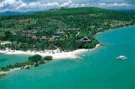 | 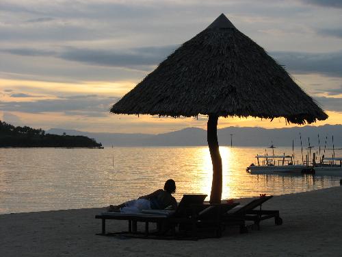 |
Sunset over badian island, off the southwestern coast of cebu island
|
Bird’s Eye – View of the Badian Island
|
"Humbly Badian"
One of the nature's ally in the preservation of its natural wonders, especially here in Cebu is the municipality of Badian.
Badian is a 3rd class municipality on the southwestern coast of the province of Cebu, Philippines. According to the 2007 census, it has a population of 35,876 people.One of the nature's ally in the preservation of its natural wonders, especially here in Cebu is the municipality of Badian.
Geographical Location
It is bounded on the:
| -Moalboal |
| -Dalaguete |
| -Tañon Strait |
| -Alegria |
Badian Information
It has a total land area of 107 square kilometers and is politically subdivided into 29 barangays. The town is situated 97.6 kilometers southwest of Cebu City. The capital barangay of Badian town is Poblacion. It is located basically in the center of the town. This is where the local high school is located called Badian National High School (BNHS)is one of the two high schools in the town of Badian. This is also the largest of the two and many students from the neighboring town just like Moalboal, Alcantara and Ronda come to study in this high school.
The lower educational facility in Badian is the Badian Central Elementary School where basically all the younger children go to school for the simple fact that it is completely free and the only elementary school and the biggest one in town. One more very important institution that is located in Poblacion is the Town Hospital where everyone from every other barangay goes to in the time of sickness. The facility has been better than the past management they have more improvements to the hospitals than anything else which is the best thing they could have done because this is where most Badianganons run to in the time of need.
The lower educational facility in Badian is the Badian Central Elementary School where basically all the younger children go to school for the simple fact that it is completely free and the only elementary school and the biggest one in town. One more very important institution that is located in Poblacion is the Town Hospital where everyone from every other barangay goes to in the time of sickness. The facility has been better than the past management they have more improvements to the hospitals than anything else which is the best thing they could have done because this is where most Badianganons run to in the time of need.
Why is the island named Badian?
This southern town got its name from a plant called, “badyang”, which was once abundant in the area. However, the Spaniards found it difficult to pronounce the name so eventually the “g” was dropped and the “y” was changed to “i” and the town came to be known as Badian, a generally mountainous and hilly area where locals and tourists go around in jeepneys and tricycles.
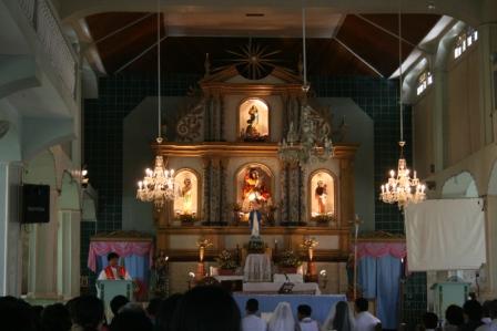
Badian Church
Formerly known as “Badyang Church”
Formerly known as “Badyang Church”
"click thumbnail for larger images"
 |
 |
Badian Church
|
Badian was separated as a parish from Barili in 1825 under the advocacy of Santiago de Apostol. Its church is unique compared to the others in the island province with its squat and unusual porticoes facade with four quadrilateral columns supporting a triangular pediment. Simple floral bas reliefs decorate these and four jar shaped finials are found at each corner.
The original belfry, now built at its side, used to sit atop the pediment but was taken down in 1990 upon the advice of NHI to ease pressure on the two free columns. The church still has its original and beautiful wooden retablo.
Badian Church, Badian, Cebu, Philippines
"Badian Assets"
Zaragosa Fish Sanctuary
Municipality of Badian, Province of Cebu
"click thumbnail for larger images"
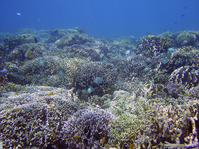 |  |  |
Zaragosa Fish Sanctuary
| ||
Badian Island Resort and Spa
Badian Island Resort and Spa
Badian boasts of breathtaking beaches, most famous of which is the Badian Island Resort and Spa. The resort has sandy beaches, a natural spa and dive center that is equipped with the best dive equipment. Instructors are around to help beginners, as well as experienced divers explore the colorful marine life in the area.
"click thumbnail for larger images"
Badian Island Resort & Spa
Room information:
Badian Island Resort and Spa has a full-service spa featuring massage/treatment rooms, facials, body treatments, and beauty services.
Area information:
Cebu Airport (CEBU) Approximate distance to Badian Island Resort and Spa is 100 km (62 miles).
Contact Information:
| Telephone: | +(63)(032) 4751103 |
| Email: | badiancebu@aol.com |
Yoga, Health and Wellness Experience
Yoga Health and Wellness Package presented to you by Ming's World Travel and Tours in cooperation with Badian Island Resort and Spa.
Agua Azul Beach Resort
Agua Azul Beach Resort, Badian, Cebu, Philippines. Beach house for rent or for sale. Entire lot. 1800 sq. meters, 5 rooms, 5 toilet and bath, all rooms are fully air-conditioned, pool and jacuzzi. House is fully furnished. Beach front. 2 kitchens. Large playroom or game rpom Table tennis, billard, videoke, etc. 3 hours south of Cebu. Contact mingsworldbizcenter.com for more details. Can house up to 20 person.
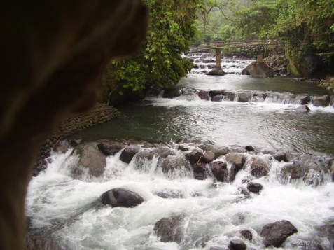
Kawasan Falls
Another must-see in Badian is the majestic Kawasan Falls, one of many waterfalls that make up the Matutinao River System, which stretches 18.35 kilometers from the Municipality of Alegria to the mouth in the Strait. Its source of fresh water comes from a large underground reservoir that emerges to the Kabokalan Springs. The river system, composed of springs, streams, and waterfalls, has been awarded several times in the past years as the Cleanest and Greenest River in the Philippines. In 2003, it earned the Hall of Fame Award for the rivers category.
"click thumbnail for larger images"
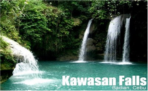
Upon arrival at Kawasan Falls, climbers may spend some time to rest their muscles and cook meals while resting before taking a dip in the cool waters. Kawasan Falls is a magnificent three-level cascade of clear spring water in Matutinao, Badian around 100 kilometers from Cebu City. The main source of the Kawasan Falls or level 3 is the first stop for climbers following the itinerary below. Level 3 is also the third water source for climbers. Cottages, rest houses, souvenir stalls, and restaurants are available mainly at levels 1 and 2. Bamboo rafts are also available for a fee. Kawasan Falls is a good venue for family and group picnics, besides a dive-and-swim in the water. The area is thickly covered with trees and plants. The Kawasan nature's park is the entry point to the river system, the Kawasan Falls and the Kabokalan Springs, which is approximately a two-kilometer uphill walk toward the Matutinao River Canyon. Different kinds of flora and fauna along the river canyon give visitors the feeling of slowly entering the forest.
Osmeña Peak
Among the Mantalongon Ranges, the Osmeña Peak is the highest peak among the Mantalongon range. Practically cutting across the island of Cebu west part, one can do the trekking across the mountain ranges. The mountain ranges stretches as far as Badian. Osmeña Peak is situated in Mantalongon, Dalaguete also known as the "Vegetable Basket" of Cebu or "Little Baguio" because of the vast vegetable farms in the area. The mountain is actually a series of rugged peaks that have been compared with the Chocolate Hills of Bohol because of its interesting formations. Osmeña Peak is considered the highest peak in the province of Cebu. The peak was named after the Osmeña family, an influential political clan in the province. Osmeña Peak is accessible all year round, but to avoid the hassle of rain and slippery pathways, it is best to climb the peak within the first half of the year. THE TRAIL to Osmeña Peak Starting from Mantalongon Market, a rough barangay road – about 1 hour to 2 hours hike – leads to the foot of Osmeña Peak. Climbers have the option to either walk or ride a "habal-habal". From the foot, the summit is around half an hour away. A water source is located along the trail to the summit. It is advisable to fetch as much water and carry it along towards the campsite or peak.
"click thumbnail for larger images"
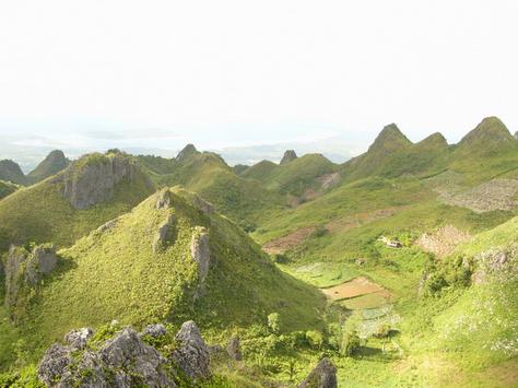
The neighboring mountain ranges of Osmeña Peak are mostly pointed and rocky, the very trade mark of the area. Some of the mountains don't have very sharp peaks and, hence, resemble Bohol's Chocolate Hills. These peaks can be likened to Bohol's native delicacy, Peanut Kisses, though. The area is somewhat bare to thinly forested because the locals are farming most of the lands. The peak area is privately owned and has been fenced. A lot keeper collects Php20 from each climber that enters the area. At the peak, one can have a 360-degree view of Cebu South [more on the southwest side] plus a sneak peek of Negros. It is not advisable to set camp at the peak and campsites are normally established a few meters down the peak. Several climbers have their own versions of ghost encounters. Years back, there were also incidents of campsite theft and robbery. However, through the efforts of the local government, the suspected thief/thieves were seized and Osmeña Peak is a relatively safer campsite once again. Barangay Tanods also patrol the area for added safety. Still, climbers are advised to be always vigilant and on-the-watch. Socials and camp gatherings at the campsite are perked up by these ghost and robbery story-telling sessions. And when feasible, climbers may do night trek up the peak to socialize there.
Matutinao River
click thumbnail for larger images"
 |
 |
 |
Matutinao River
|
Matutinao River is where the famous Kawasan Falls of Badian, Cebu lies. It is your companion during the 30-minute luxurious trek from the main road to the waterfalls. I say "luxurious" because one doesn't need to know rapelling, climing or any of those stuff to reach the waterfall. One can walk as he looks around to appreciate the green. I do not recommend this to those who are up for a more challenging adventure.
This one more tourist-friendly. Locals have built bridges and large trails with a reasonable entrance fee of 10 Philippine Pesos. Sadly, as we go closer to the main waterfall, more food stalls color the area making Kawasan more commercialized thaCoca-cola-marked wooden table would cost 200 pesos. Food is also expensive. I'd rather have mine home-cooked and packed for the trip. As a nature-lover, I can only suggest that store-owners paint their stores brown (as in the color of the woods) to make them look natural than eyesores.
"TRANSPORTATION"
"click thumbnail for larger images"
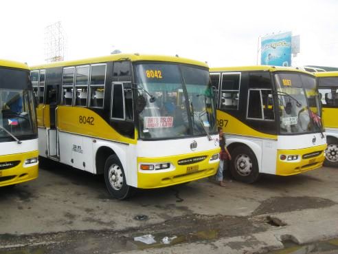
Cebu South Bus Terminal
ROUTES
|
MEANS OF TRANSPORTATION
|
Capacity
|
Accessibility
|
Fares*
|
| CSBT-South | Buses (aircon) | 66(max) | CSBT (Cebu South Bus Terminal) | P85-P120 |
| CSBT-South | Buses(non-aircon) | 66(max) | CSBT (Cebu South Bus Terminal) | P65-P80 |
| CSBT-South | Mini Buses | 40(max) | CSBT (Cebu South Bus Terminal) | P55-P70 |
| *Fares vary depending on the destination point. | ||||

Badian Municipality is administratively subdivided into 29 Barangays.
|
|
|
|
|
|
|
|
|
|
|
|
|
|
|
|
|
|
|
|
|
|
| |
|
| |
|
| |
|
|
Subscribe to:
Posts (Atom)